City hall nearby Brgy Mojon Hall
Philippines
City hall nearby Brgy Mojon Hall
Brgy Mojon Hall
Malolos Philippines
contacts phone
:
+63
Latitude:
14.8608822
, Longitude:
120.8173692
read more
nearest City hall
1.481 km
Pamahalaang Barangay Ng Caniogan
Kabihasnan Road, Caniogan Malolos, Bulacan
City hall
read more
2.023 km
City Hall of Malolos
Malolos
City hall
read more
2.322 km
Dakila Barangay Hall
Malolos
City hall
read more
2.809 km
Baranggay Hall of Pulo, Barihan
E1, Malolos
City hall
read more
4.186 km
Paombong Municipal Hall
Paombong
City hall
read more
4.944 km
Pamahalaan ng Barangay San Jose
Bulacan
City hall
read more
5.388 km
Plaridel Municipal Hall
Plaridel
City hall
read more
5.638 km
Pulilan Municipal Hall
Pulilan
City hall
read more
6.246 km
Iba Barangay Hall
Hagonoy
City hall
read more
16.1 km
Brgy. Sto Tomas Hall
Evangelista Street, Santa Maria
City hall
read more
16.354 km
Our Mother Of Perpetual Help
Mahogany Town & Country Subd., Marilao
City hall
read more
16.808 km
Pamahalaang Barangay ng Duhat
H.Capiral Street, Bocaue
City hall
read more
18.2 km
Marilao Old Municipal Hall
174 Sandico, Poblacion 2, Marilao
City hall
read more
21.706 km
Meycauayan City Hall
Meycauayan
City hall
read more
22.05 km
San Pedro Baranggay Hall
San Pedro Road, San Fernando
City hall
read more
22.834 km
City Hall of San Fernando, Pampanga
San Fernando Bridge, San Fernando
City hall
read more
24.385 km
Barangay Hall Fatima 2
Sapang Palay, San Jose del Monte City
City hall
read more
24.806 km
Barangay Hall Fatima I
San Jose del Monte City
City hall
read more
24.85 km
Valenzuela City
MacArthur Highway, Valenzuela
City hall
read more
24.898 km
Barangay Hall
San Jose del Monte City
City hall
read more
24.987 km
Mexico Town Hall
Mexico
City hall
read more
25.987 km
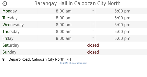
Barangay Hall
Brgy.168, Deparo Road, Caloocan City North
City hall
read more
26.756 km
Malabon City Hall
F. Sevilla Boulevard, Malabon
City hall
read more
28.285 km
Libra Brotherhood Multi-purpose Cooperative
412-A Compound Samson Road, Caloocan
City hall
read more
30.958 km
Sindalan Barangay Hall
San Fernando
City hall
read more
📑
all categories
Accounting
Administrative area level 1
Administrative area level 2
Airport
Amusement park
Aquarium
Art gallery
Atm
Bakery
Bank
Bar
Beauty salon
Bicycle store
Book store
Bowling alley
Bus station
Cafe
Campground
Car dealer
Car rental
Car repair
Car wash
Casino
Cemetery
Church
City hall
Clothing store
Colloquial area
Convenience store
Courthouse
Dentist
Department store
Doctor
Electrician
Electronics store
Embassy
Finance
Fire station
Florist
Food
Funeral home
Furniture store
Gas station
General contractor
Grocery or supermarket
Gym
Hair care
Hardware store
Health
Hindu Temple
Home goods store
Hospital
Insurance agency
Intersection
Jewelry store
Laundry
Lawyer
Library
Light rail station
Liquor store
Local government office
Locality
Locksmith
Lodging
Meal delivery
Meal takeaway
Mosque
Movie rental
Movie theater
Moving company
Museum
Natural feature
Neighborhood
Night club
Painter
Park
Parking
Pet store
Pharmacy
Physiotherapist
Place of worship
Plumber
Point of interest
Police
Political
Post office
Premise
Real estate agency
Restaurant
Roofing contractor
Route
Rv park, camping
School
Shoe store
Shopping mall
Spa
Stadium
Storage
Store
Sublocality
Subpremise
Subway station
Supermarket
Synagogue
Taxi stand
Train station
Transit station
Travel agency
University
Veterinary care
Zoo
administrative area level 3
administrative area level 5
sublocality level 1
↑