Cafe nearby Blends Project
Philippines
Cafe nearby Blends Project
Blends Project
Hippodromo, Makati Filipinas
contacts phone
:
+63
Latitude:
14.5721733
, Longitude:
121.0180738
read more
nearest Cafe
147 m
Thread and Coffee
3246 Zapote, Makati
Cafe
read more
208 m
Cynatic Computer Cafe
3243 Zapote, Makati
Cafe
read more
293 m
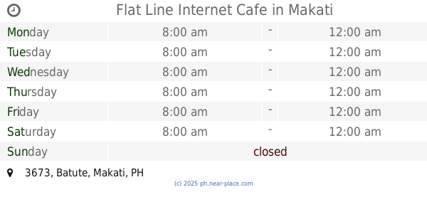
Flat Line Internet Cafe
1204, 3673 Batute, Makati
Cafe
read more
294 m
Cafe La Carmela
Bel-Air Jupiter St. Bel-Air, Makati
Cafe
read more
337 m
Ichiro's Sweet Shop
Olympia
Cafe
read more
345 m
The Coffee Bean, & Tea Leaf.
Makati
Cafe
read more
364 m
Icelavie Philippines
West Gala, Makati
Cafe
read more
371 m
Best Brew Coffee Solutions, Inc
G/F Alexandria Residences, Montojo St cor Zapote St, Makati
Cafe
read more
427 m
Raidzone Net Cafe
2931 H. Santos, Makati
Cafe
read more
475 m
Black Canyon Coffee
Ground Floor, Ayala Malls, Circuit Lane, Makati
Cafe
read more
495 m
Tony's Place
7102-7374 Kalayaan Avenue, Makati
Cafe
read more
575 m
Pinky & Baboy's Tina & Tommy's
Visita, Makati
Cafe
read more
591 m
9020 Hormiga Corner Pateros Street
9020 Pateros, Makati
Cafe
read more
671 m
Manna Cafe
9719 Pililla Street Cor Baler Street, Makati
Cafe
read more
800 m
Up Cafe
3650, Davila Street, Makati
Cafe
read more
865 m
Giscelle's
A. Bilog, Mandaluyong
Cafe
read more
883 m
Brenda Chanel
Manila
Cafe
read more
891 m
HK Tea House
1012 Metropolitan Avenue, San Antonio Village, Makati
Cafe
read more
918 m
Caffe Caruso
210 Nicanor Garcia Street, Makati
Cafe
read more
968 m
Galli Village Cafe
YMCA/ Jn. niorales Bldg, 7 Sacred Heart Street, San Antonio Village, Makati
Cafe
read more
1.008 km
Pledge Legacy Corporation
Neptune Street, Makati
Cafe
read more
1.032 km
Serenitea
Makati
Cafe
read more
1.135 km
Ambivert Coffee
7612 Guijo, Makati
Cafe
read more
1.216 km
Infinitea
Harmonic Building, Pedro Gil Street, 876 Santa Ana, Manila
Cafe
read more
1.288 km
High Sprits Internet Cafe
Saint Paul Road, Makati
Cafe
read more
📑
all categories
Accounting
Administrative area level 1
Administrative area level 2
Airport
Amusement park
Aquarium
Art gallery
Atm
Bakery
Bank
Bar
Beauty salon
Bicycle store
Book store
Bowling alley
Bus station
Cafe
Campground
Car dealer
Car rental
Car repair
Car wash
Casino
Cemetery
Church
City hall
Clothing store
Colloquial area
Convenience store
Courthouse
Dentist
Department store
Doctor
Electrician
Electronics store
Embassy
Finance
Fire station
Florist
Food
Funeral home
Furniture store
Gas station
General contractor
Grocery or supermarket
Gym
Hair care
Hardware store
Health
Hindu Temple
Home goods store
Hospital
Insurance agency
Intersection
Jewelry store
Laundry
Lawyer
Library
Light rail station
Liquor store
Local government office
Locality
Locksmith
Lodging
Meal delivery
Meal takeaway
Mosque
Movie rental
Movie theater
Moving company
Museum
Natural feature
Neighborhood
Night club
Painter
Park
Parking
Pet store
Pharmacy
Physiotherapist
Place of worship
Plumber
Point of interest
Police
Political
Post office
Premise
Real estate agency
Restaurant
Roofing contractor
Route
Rv park, camping
School
Shoe store
Shopping mall
Spa
Stadium
Storage
Store
Sublocality
Subpremise
Subway station
Supermarket
Synagogue
Taxi stand
Train station
Transit station
Travel agency
University
Veterinary care
Zoo
administrative area level 3
administrative area level 5
sublocality level 1
↑