Local government office nearby DAR Municipal Agrarian Reform Office
Philippines
Local government office nearby DAR Municipal Agrarian Reform Office
DAR Municipal Agrarian Reform Office
Calinan District, Davao City Philippines
contacts phone
:
+63
Latitude:
7.1909456
, Longitude:
125.4557605
read more
nearest Local government office
53 m
Kean Gabriel Hotline
QRTCC building, Claro M. Recto Ave, Davao City
Local government office
read more
384 m
Social Security System
Calinan, Davao City
Local government office
read more
389 m
Department Of The Interior And Local Government
Calinan, Davao City
Local government office
read more
2.221 km
Office Of The Municipal Agricultural Officer
Calinan-Baguio-Cadalian Road, Malagos, Baguio District, Davao City
Local government office
read more
5.989 km
Lamanan Health Center
Calinan-Paquibato Road, Lamanan, Calinan, Davao City
Local government office
read more
6.003 km
BARANGAY HALL LAMANAN
Calinan-Paquibato Road, Calinan District, Davao City
Local government office
read more
6.098 km
City Treasurer's Office
Calinan-Baguio-Cadalian Road, Baguio Proper, Baguio District, Davao City
Local government office
read more
6.106 km
Baguio Teachers Multipurpose Cooperative
Baguio Road, Baguio, Davao City
Local government office
read more
6.134 km
City Social Services And Development Office (CSSDO)
Baguio Proper, Baguio District, Davao City
Local government office
read more
6.138 km
Peso Public Employment Service Office
Baguio Proper, Baguio District, Davao City
Local government office
read more
8.098 km
Angalan Barangay Hall
Tugbok, Davao City
Local government office
read more
9.2 km
Barangay Health Center
Tawan-Tawan, Baguio Dist, Davao City
Local government office
read more
9.367 km
Office of the Barangay Council
Davao City
Local government office
read more
10.393 km
Department of Public Works and Highways
Tugbok, Davao City
Local government office
read more
11.876 km
VERTUDAZO AH26*
Unnamed Road, Tugbok, Davao City
Local government office
read more
11.943 km
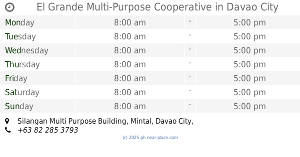
El Grande Multi-Purpose Cooperative
Silangan Multi Purpose Building, Mintal, Davao City
Local government office
read more
12.283 km
MINTAL HEALTH CENTER
Gumamela Street, Tugbok, Davao City
Local government office
read more
12.936 km
Revenue Collection Center
Davao-Bukidnon Road, Sto Niño, Mintal, Tugbok,, Davao City
Local government office
read more
13.075 km
HEALTH CENTER
Evergreen Street, Tugbok, Davao City
Local government office
read more
15.205 km
NAJER Drug Testing Center
Door 5, RMA Building, Moses Street, Talomo, Davao City
Local government office
read more
15.572 km
Catalunan Grande Health Center
Catalunan Grande Road, Talomo, Davao City
Local government office
read more
16.379 km
Uspd Savings & Credit Cooperative
Door 1, Plaza De San Isidro, Skyline, Catalunan Grande, Davao City
Local government office
read more
18.966 km
LTFRB
Balusong Avenue, McArthur Highway, Matina, Davao City, 8000, Davao del Sur
Local government office
read more
19.331 km
City Social Services And Development Office
Aries Street, Talomo District, Matina, Davao City
Local government office
read more
19.357 km
City Treasurer Office (Talomo District)
Talomo, Davao City
Local government office
read more
📑
all categories
Accounting
Administrative area level 1
Administrative area level 2
Airport
Amusement park
Aquarium
Art gallery
Atm
Bakery
Bank
Bar
Beauty salon
Bicycle store
Book store
Bowling alley
Bus station
Cafe
Campground
Car dealer
Car rental
Car repair
Car wash
Casino
Cemetery
Church
City hall
Clothing store
Colloquial area
Convenience store
Courthouse
Dentist
Department store
Doctor
Electrician
Electronics store
Embassy
Finance
Fire station
Florist
Food
Funeral home
Furniture store
Gas station
General contractor
Grocery or supermarket
Gym
Hair care
Hardware store
Health
Hindu Temple
Home goods store
Hospital
Insurance agency
Intersection
Jewelry store
Laundry
Lawyer
Library
Light rail station
Liquor store
Local government office
Locality
Locksmith
Lodging
Meal delivery
Meal takeaway
Mosque
Movie rental
Movie theater
Moving company
Museum
Natural feature
Neighborhood
Night club
Painter
Park
Parking
Pet store
Pharmacy
Physiotherapist
Place of worship
Plumber
Point of interest
Police
Political
Post office
Premise
Real estate agency
Restaurant
Roofing contractor
Route
Rv park, camping
School
Shoe store
Shopping mall
Spa
Stadium
Storage
Store
Sublocality
Subpremise
Subway station
Supermarket
Synagogue
Taxi stand
Train station
Transit station
Travel agency
University
Veterinary care
Zoo
administrative area level 3
administrative area level 5
sublocality level 1
↑